

Configuration
The options that are available when you select Surveying | Configuration are used to configure how data is calculated and displayed in the Development Advance window.
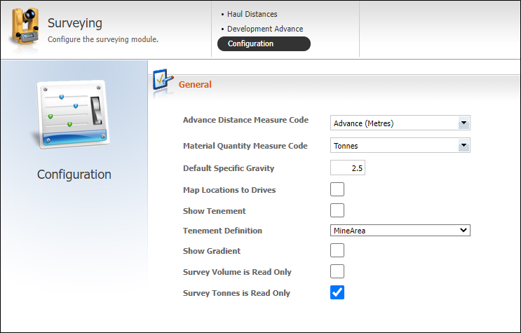
General
| Option | Description |
|---|---|
| Advance Distance Measure Code | Defines the measure token (configured in Reference Edit) that will display the Claimed advance measure. The measure can be either Metres, Feet or Yards Advanced. If, for example, the selected measure type is Metres Advanced, when the drilling is complete the jumbo or drill operator will call in the Metres Advanced value for the drive to the Control Room Operator. |
| Material Quantity Measure Code | Define the material type (Tonnes or Tons, for example) of the movement from the source to a dump or ore pass. The code is entered into the Claimed | Tonnes column of the Development Advance workspace. |
| Default Specific Gravity | This value is used to quantify the Survey Tonnes. It is the weight of material extracted from the advance where:
|
| Map Locations to Drives | A drive can be defined as a single location or may be made up of a number of locations. If this option is selected, only the main location will be displayed, not the individual locations that make up the drive. The Chainage will be the summation of the individual advances. If this option is not selected., each advance will be displayed as a location with a separate Claimed | Advance (m). For this option to function you must have the attribute Drive defined for the location token. To achieve this, in Reference Edit you need to define a Drive type. This is performed in Surveying | Drive. |
| Define a location | Define a location with a Drive attribute (one of the defined Drive types). This is achieved in Pitram | Locations | Location. Select a value for the Drive attribute of the location. |
| Show Tenement | Select this option to include a Tenement column in the Development Advance workspace |
| Tenement Definition | If Show Tenement has been selected, this option defines the location attribute that identifies the tenement. For example, the attribute could have the values of Zone or MineArea, In the workspace, the selected attribute will be displayed as a column. Select the value of that attribute from the drop-down list. If the check box is not selected, only the default set of columns will be included. |
| Show Gradient | Select this option to display the gradient of the drive in the Development Advance workspace. |
| Survey Volume is Read Only | Select this option to ensure that the values in the Volume column of the Development Advance workspace will be read-only. |
| Survey Tonnes is Read Only | Select this option to ensure that the values in the Tonnes column of the Development Advance workspace will be read-only. |
Save Configuration
Finally, click Save Changes.