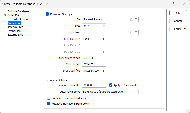
Survey File
If downhole data is being used, then the data in a Collar file and (optionally) a Survey file can be imported and used to generate trace coordinates.
Downhole surveys
If survey data is to be used to generate the drillhole trace, select the Downhole surveys check box.
File
Specify a Survey file, and enter field settings. You can also click the Pick from Vizex button to collapse the form and interactively select a layer containing the file to be inserted and return to the form.
Optionally, select or create a filter to limit the data that is processed.
Hole ID fields 1, 2, 3
Double-click to select the name of the fields that uniquely identify each hole in the file. Up to 3 Hole ID fields can be specified.
This can be useful, for example, when the holes imported from disparate datasets are known to have duplicate keys. When more than one Hole ID is specified, a unique ID (a concatenation of the Hole IDs) is used to query the database.
Survey depth field
Enter the name of the depth field in the Survey file. Survey depths must be in increasing order for each hole.
Azimuth field
Enter the name of the field containing drillhole azimuths. Azimuths are expressed in decimal degrees, with zero (0°) being grid North. Negative values and values greater than 360° are correctly evaluated.
Inclination field
Enter the inclination field of the Survey file. Inclinations are expressed in decimal degrees from -90 to 90, with negative values representing down holes.
Desurvey Options
The Desurvey options are used to configure the desurvey process by specifying any required Azimuth correction, selecting a desurvey method and configuring curve and inclination options.
Azimuth Correction
Optionally apply an Azimuth Correction.
Apply to 1st azimuth
Select this option to apply the azimuth correction to the first and all subsequent azimuths.
Do not apply the azimuth correction to the first azimuth when collar surveys have an azimuth taken in terms of grid North and subsequent downhole azimuths are taken in terms of magnetic bearings.
Desurvey method
Use the drop down list to select the required desurvey method for the database.
-
Spherical Arc (Standard Accuracy) - Standard method with an accuracy of 0.05m.
-
Spherical Arc (High Accuracy) - Default method with extended accuracy of 0.001m.
Note: Drillhole Databases created prior to Micromine Origin & Beyond v26.5 will default to Standard Accuracy.
-
Spherical Arc (Very High Accuracy) - Advanced accuracy of (0.0005m)
-
Balanced Tangent - Uses a calculation method which treats half of a measured distance as tangent to the first survey point Inclination and Azimuth and the remainder of a second measured distance as being tangent to the next survey point Inclination and Azimuth. This is the least accurate method, but is best for backward compatibility with legacy applications.
For more information on the calculation of curves, see Trace Calculation and How is the trajectory of a hole calculated?.
Continue curve past last survey
Select this option to extend the trace by the trend of the calculated curve to the full depth of the survey.
Straight holes are always depicted with two points – one at the collar, and another at the end of hole. Curved holes are given a trace interval that varies according to the curvature of the hole; the more curved the hole, the shorter the trace interval and the more points required to draw it.
If the deepest survey point is not at the end of the hole, a new inclination and azimuth is calculated, consistent with the way those angles have been changing down the drillhole and the curve is continued on the calculated trajectory to the end.
If this option is OFF, the last inclination and azimuth survey in the Survey file is used from the point of the last survey to the end of the hole and the trace will extend straight to the full depth. No curve will be calculated.
Negative inclinations point down
The Negative inclinations point down option is selected by default. This is because Micromine Origin & Beyond considers negative inclinations in a drillhole survey file to mean that the hole points downward.
Files from other sources can in some instances can be the opposite - i.e when drillholes are first imported, they can come in upside down. Deselect the option to treat positive inclinations as downward.